ENTER THE COLISEUM
by Harry Hubbard
November, MMI
Note: The links in this Coliseum -- a work of non-fiction -- may take a long time to download. Please be patient when using them.
Dr. Glen Kimball has recently become a frequent guest on the Coast to Coast AM program primarily hosted by Art Bell. In November of 2001, Kimball was again Art's guest being featured for three hours of the show. Due to the fact that Kimball distorted so many facts and used false ploys on Art's listeners, I decided to dedicate this page of our web to correcting these mistakes thus allowing all who enter here the opportunity to learn more about the project that Kimball is affiliated with. The site where Kimball, May, Wolak et. al. are digging and testing is located in the far north eastern corner of Richland County, Illinois. Their site is located 1/2 mile north of where the 1700N intersects with the 1800E. There is a field road heading to the east from that point leading into a corn field. Just after one gets off the 1800E and heads east, there is another tire-beaten path on the left that hugs the tree line circling around the corn field on the north side. About midway across the field, there is an opening in the woods they use to access the site shown to them by Russell Burrows in late winter of 1999 who staged a fiasco causing the group to earnestly believe his false story. The property in question is owned by an elderly man named Leroy Boughan, Section 34, East; German Township. The property is managed in part by his son, Donald Boughan. Both men live about a mile from the site and no one lives down any of the access roads leading to the property in question.

As with all newcomers to the saga, it is my duty to clarify any and all distortions, rumors and falsehoods created by those who somehow believe they can get closer to the access of the Lost Tomb by going through Russell Burrows. As I have stated time and time again, Burrows will never divulge any more accurate information to anyone and will take the true story to his grave (which is his only option). To do otherwise, would cause a severe self-inflicted wound that he fears more than anything else in the world -- Prison Time!
Kimball had been a guest on the Coast to Coast program several times prior to this appearance. He had worked up the ranks from Mike Siegel to Ian Punnett and finally made it to Art Bell. Art's listeners were anticipating the show with fervent diligence having been subject to a tremendous amount of publicity prior to the show. Art has several million listeners and the night this program aired, over 50,000 persons logged on to his website to see and learn more about the mysterious cave located in southern Illinois that housed a treasure trove of gold artifacts from Egypt. What they got instead was a barrage of broken bits and pieces along with Kimball's epicyclical history attempting to justify certain personal claims and theories.
It all started like this: During winter of 1999, May (owner of Ancient American magazine) and Wolak (FOX Publications) sought to give Russell Burrows a very large sum of money to show them the location of the underground tomb that he had found in 1982 and subsequently looted over the next nine years. The agreement was initiated by presenting Burrows with $5000 cash. This same group had already given Russell's brother-in-law, Sam Eyer of Olney $3600 to take them to the site, but Russell threatened to kill him as he had done with others. Thus, Sam got cold feet and took Wolak to a bogus site; a deserted coal mine located in Franklin County. Sam Eyer scammed out with Wolak's money and left them hanging on a string. Russell Burrows had already misguided Wayne May and Frank Colin five times previously to different sites all over the Midwest. One would have to wonder how many times it would take for May to learn that he will never be escorted to Russell's treasure trove.
After Wolak presented the cash to Burrows, he took them to the site they are now excavating at, pointed to the ground and told them to dig here. There was a picture to attest this fact printed in Ancient American issue #28 under the heading: Find of the Century Revealed. While Burrows was out showing the property to Wolak, May et. al., he pretended to receive a call on his cell phone where he next informed the newly re-duped crew of adventurers that they had to leave the property immediately. So right away, the group gathered together and left the site returning to their motel rooms. Later that same afternoon while the group was contemplating their elation, Burrows informed them that he had to leave and catch a flight out of St. Louis, that an emergency back in Windsor, Colorado (where he currently resides) required his expedient presence. Russell then quickly left his new partners at the motel and booked.
After Burrows left, the group pondered as to what they should do next feeling remorseful that they had been left poised with such a dutiful task as such at hand. They convened a meeting where one of the party got the brilliant idea to obtain a Richland County Plat Book and from there, they would discover who owned the site Burrows had taken them to. The next morning, the Plat Book was purchased and the group learned who the owner of the property was. They contacted Mr. Boughan and set up an appointment with him. While the group was at Mr. Boughan's abode, the phone rang and Mr. Boughan answered it. The caller was none other than Burrows himself who painstakingly acted a well rehearsed pretend-game regretting and apologizing to the landowner about being on his land and that he shouldn't allow the group of outsiders on his property, that they were nothing but a bunch of pot-hunters trying to find treasure to exploit their own interests. Then Burrows made contrived statements, verbal gestures and bewildering accusations designed to lead the group and landowner to actually believe that an archaeological cavern did indeed exist on the site. What the group did not realize at the time is that Burrows hadn't left Olney at all and there never was an emergency. Russell had staked out Mr. Boughan's house from a short distance to the north on the 1900E road, cleverly out of sight to the passersby. When he saw them enter Mr. Boughan's dwelling, he used his cell phone to make the call and put on his suspicious act.
Thus, played like a fiddle, the party bought into Russell's premeditated scam and this Search Agreement with the landowner was secured. By this time, May had been teasing Kimball (whom he had only recently met) about an incredible archaeological find in southern Illinois. Kimball was wrought with excitement as May led him from story to story about ancient cadavers, gold, scrolls and such. Kimball joined forces with May during summer of 1999. Kimball was the type of man naive enough to believe just about anything told him. May was the type that would say anything to make his image or his magazine appear more esteemed, and he is always on the lookout for potential Ph.D.'s to add to his masthead. The two began working together and May continued to present false information to Kimball and lead him on with his own version of the events that had transpired concerning the tomb in Illinois.
By fall of 1999, the site was dubbed the "Stringtown Tomb." Various people associated with May came from many different places to the site to aid and assist with the location and entry to the alleged caverns. They preformed several tests at the site with Ground Penetration Radar and obtained some very colorful results. The detailed slats and overlay results appeared to be astounding! The group was elated they found the cave's location and all to do now was to excavate at a certain point to gain entry. There was only one problem: The group was very unfamiliar with the GPR unit and had never tested ground before. Thus, it turned out, that the software program used to communicate between the Control Sensor Module and the laptop they were using was configured improperly making the data come out with some beautiful colors of mistranslated-keycode colors never even seen before. The group was astounded with the data printout-slats, but the member of the group who owned the laptop and GPR unit informed them that their testing was trashed and that it should be done again. Then it was learned that the raw data was still on the drive within the unit. The owner of the unit was glad to hear this and wanted them to send the raw data to him that he might print up the new slats and present them for consultation with his hired Geophysicist (who truly is a brilliant man, Mr. Daniel Woods). The field leaders, May and Wolak, didn't want this to happen under any circumstances. They had already shown the slats to several people (Kimball included) and bragged so much, that if anything were proven untrue by reprocessing the raw data, they would most certainly lose credibility making solicitation for additional funds more difficult to be sure. The owner of the unit, who was a staunch financial backer having sunk a big wad of change into the project, demanded that it was essential to send him the unit as soon as possible. However, such did not occur. Instead, Wolak, in an attempt to trash the data, went inside the machine and removed several internal fuses which caused the power module in the unit to fail completely. Upon reassembly, Wolak broke several switches on the face of the unit and on the rear exhibiting very little electronic skill and prowess.
When the unit was well beyond functioning, and wouldn't even turn on, Wolak contacted Harry Hubbard, who was in the area. Harry Hubbard is familiar with all the ancient sites in southern Illinois including the actual location of the cave Kimball and others believe they have found. Wolak knew that Harry was familiar with GPR, as well as various other units of this sort, and requested his services to meet in Olney for the purpose of repairing the unit in his motel room. Harry laughingly agreed to assist Wolak and went to Olney with his electronics test gear and electrical tools. Upon the first diagnostic attempt, it was discovered that several internal components were totally trashed and that retrieving any data from the storage drive would be impossible. Wolak contacted the owner and informed him as instructed by what Harry had told him to say. The owner of the unit was in agreement with Harry's diagnostics and realized his unit (which cost $40,000) was trashed. The owner of the unit then contacted the dealership in Florida to see if he could obtain board schematics so Harry could begin repair, but such was unavailable. The dealership insisted that the unit would have to be shipped back to the manufacturer for repair at the owner's expense. The factory was located in Latvia, so the unit would most likely be gone for several months. A severe degree of anger was displayed at that time by the investor towards Wolak. Wolak packed up and left town the next morning.
To this day, that same color slat is presented and claimed to show everything from mummies on stone biers, to statues, coffins of gold, underground rooms; whatever the group wishes to see. This is where we are now. The only thing that's changed is the name of the site which is now called, "The Chickasaw Treasure Trove." It is this site that Kimball emphasizes and teaches about in lectures, interviews and speeches. The reason Kimball always says, "...no comment..." when asked if this is the same site referred to by Robert Ghost Wolf and Dannion Brinkley is because Ghost Wolf was associated with this group from the beginning and Kimball is still contractually bound to the deal with Ghost Wolf. Ghost Wolf is now opposing the group for destroying not only the owners property, but also tearing up a site that truly was an old Indian camp at one time. Ghost Wolf saw the illegitimacy of Burrows in the beginning and was not to be fooled. He still persists to put an end to the fiasco based on bad data from a useless GPR readout.
Now let us review the images Kimball is using to convince others that he is on the verge of the greatest discovery of all time.
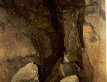
First of all, I will give a history of Figure 1. The photograph shown here was first presented to Virginia Hourigan in 1988 by Russell Burrows who claimed that he took it from inside the cave. It is obviously a cavern of some sort, but you'll notice that there is plenty of space to stand, walk and move about. Burrows always told everyone that he had to crawl on his belly to access the cave. It would be very difficult, however, to haul artifacts back and forth over such rough terrain within a cave corridor, much less bodies, mummies and large statues as alleged by Burrows. There is no proof that this picture is actually taken from the cave Burrows was looting. But rather, it looks like any typical cave attraction often seen in Indiana and Ohio where this photograph was most likely taken.

Figure 1.
Figure 2 is the GPR readout processed with the wrong transfer program and used to corroborate the amazing discovery. Anyone who has ever used GPR knows that the unit does not penetrate very far down into the soil. I've only been able to go 21 feet down with the most modern unit over bare, soft sandstone. It would be impossible for any GPR unit to penetrate to the depths Kimball and his group claim. The picture truly is beautiful, but you will notice there is no information concerning parameter settings, depth, or distances on the slat. Every time I do this procedure, I have to put all the important nomenclature and test calibrations right on the slat itself to accept full responsibility for its accuracy and dissemination. Where is the company logo on this test printout? Who is solely responsible for it being right or wrong?

Figure 2.
Figure 3 is a hand-drawn test result which is the first clue that it is contrived to mean whatever its composer wishes to depict. You will notice there is a box in the upper right corner labeled EM PROFILES. This means that an EM unit, most likely manufactured by Accurate Locators in Oregon, was the unit they used, either the EM-83 or the updated version of the same unit. I have used the EM unit extensively and can comfortably state that it is a very general result unit and not accurate to any degree of precision. When tested over a railroad truss, the unit will show that something is there, but that's about it. There is no detail at all that can be interpreted with convincing accuracy. This particular readout suffers the same ailments as the other evidence also. Where is the company logo? Where are the setting parameters shown? How do we know that this just isn't concocted when we don't even know who drew it? You will notice that on LINE F there is "50' coil separation" listed above the line. This means that the controller was in the middle and 25' of line separated the antennae coils. This translates to about 45 feet of penetration down into the subsurface; still, a depth far less than claimed. Anyone who has extensive knowledge of the unit and its operational procedures would quickly realize that this drawing doesn't mean anything. It isn't even computer generated. Should we be convinced it shows cavern filled with gold given so much potential margin of human error? One could just as easily assume that LINE H might even be a well endowed woman lying on her back. This evidence is absolutely inconclusive.

Figure 3.
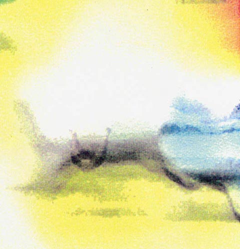
Figure 4 is also a beautiful color picture, however, how do we know if it is a computer generated printout? Again, there is no information on this alleged slat. What determines if the picture is upside down or not? Where is the nomenclature? Where is the scale? This could be a flash picture taken in front of a mirror and enhanced with an Adobe program. What evidence is there that this picture isn't a watercolor painted by a child? Yet this picture was used to convince an audience of millions that there is a statue of Jesus with his hands outstretched in purple towards the bottom center of the illustration. Did anyone ask or offer to divulge exactly what brand name of unit was used to obtain these results?

Figure 4.
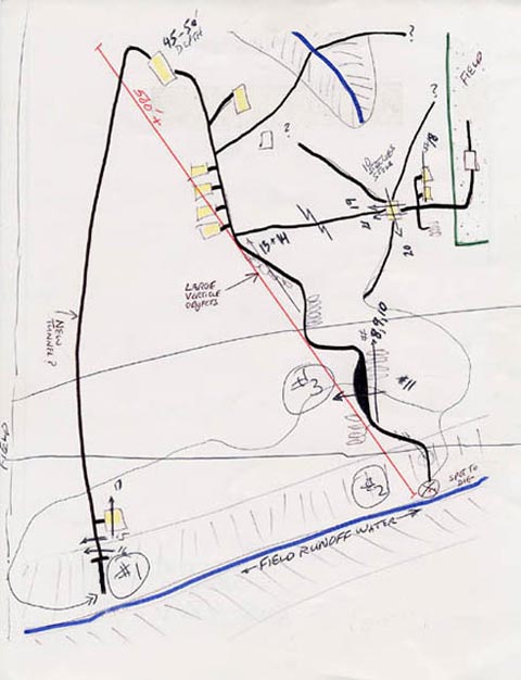
I have saved Figure 5 for last because every discrepancy made aware concerning the previous illustrations applies here, plus a few extra's. Again, we have a hand-drawn picture subject to gross negligence and human error. There are lines that zigzag and cross each other everywhere. How do we know this from the surface given the information used in creating this map of the site. The map indeed shows some similarity to the actual topography of the site itself, yet why are there no directions listed? Which way is north? Where is the index scaling? Where is the nomenclature? Who drew this picture in the first place? All questions yet to be fully answered. This illustration is the biggest joke I've ever seen, but maybe it's just me. Kimball stated that his field crew was going to commence drilling at the wide, black spot indicated with an arrow situated between the #3 and #11. The area above the #20 marker, where several of the lines come together, is where the group dug two large holes with a trackhoe. The trackhoe sat right on top of the two arrows pointing the same direction. The holes are now filled up with debris and large dead trees moved over the tops of them, but when the holes were open, I climbed down in them and saw nothing but sandstone and dirt. Any excavator or geologist familiar with this area so near the Embrass River will attest that one would most certainly strike water before reaching a depth of 110 feet.

Figure 5.
All in all, if these elementary hand drawings and paintings were all I had to convince my field crew that we were at the right location to dig for an ancient tomb, I would be laughed at.
These are a few of the artifacts displayed on Art Bell's homepage.
Footnote: When this article was first circulated, I challenged anyone to correct any mistakes I may have made in the text. Alas, one has stepped forward to ask that I footnote the article with these corrections to make the issue as clear as possible. Hence, in my effort to be precise with factual data, you can see my mistakes by clicking here.